
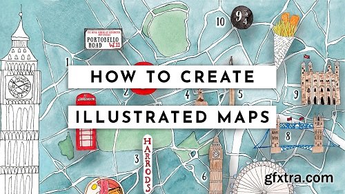
In this class, you will learn my method to create illustrated maps that combine analogical (watercolour for me) & digital illustration.
We will start by understanding what a map is and it's key features. Then we will start to plan what we want to include: the locations and the icons to represent them. We will then move to look for reference, create a customized Google map, define a palette, choose fonts and so on.
The fun part will be to illustrate our icons and the map background individually. We will import them in Photoshop and assemble together to create our map. Disclaimer: This class is not focused on teaching watercolour or sketching technique itself nor on technical Photoshop skills. It's designed to combine both of those skills to create an illustrated map, that's why is suggested to intermediate level students. If you want to start learning watercolour sketching and/or how to digitize your artworks from scratch I suggest you take my food sketching series classes first, so you will have all the beginner's skills needed to approach this class successfully. More info - https://skl.sh/2Yu6MED 

Top Rated News
- Sean Archer
- AwTeaches
- Learn Squared
- PhotoWhoa
- Houdini-Course
- Photigy
- August Dering Photography
- StudioGuti
- Creatoom
- Creature Art Teacher
- Creator Foundry
- Patreon Collections
- Udemy - Turkce
- BigFilms
- Jerry Ghionis
- ACIDBITE
- BigMediumSmall
- Boom Library
- Globe Plants
- Unleashed Education
- The School of Photography
- Visual Education
- LeartesStudios - Cosmos
- All Veer Fancy Collection!
- All OJO Images
- All ZZVe Vectors
