
Unity: Integrating GPS and Points of Interest
MP4 | Video: h264, 1280x720 | Audio: AAC, 48 KHz, 2 Ch | Duration: 3h 57m
Genre: eLearning | Language: English + Sub
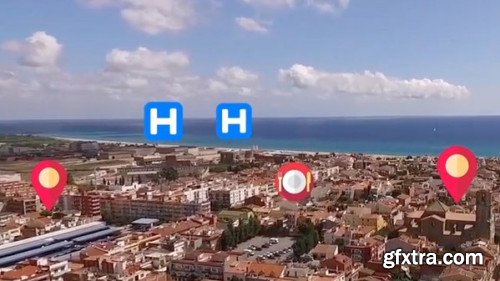
Geographic data is at the heart of much of the large-scale augmented reality work out there, but adding it to projects takes finesse. In this hands-on course, instructor Diego Herrera lays out the process, showing beginners how to use GPS inside Android and iOS applications. Throughout the course, Diego details how to load information from the Google Places API and process the JSON code successfully inside Unity. Learn how to set up an augmented reality camera, as well as how to build a fully-functional application that can sort results by distance. Topics include: Setting up an AR camera Building a scrolling menu Creating a scene controller Using Unity to load data from a website URL Refactoring code Populating a virtual object with JSON data Calculating distance using GPS Sorting results Homepage: https://www.lynda.com/Unity-tutorials/Unity-Integrating-GPS-Points-Interest/5016722-2.html 

Top Rated News
- Sean Archer
- AwTeaches
- Learn Squared
- PhotoWhoa
- Houdini-Course
- Photigy
- August Dering Photography
- StudioGuti
- Creatoom
- Creature Art Teacher
- Creator Foundry
- Patreon Collections
- Udemy - Turkce
- BigFilms
- Jerry Ghionis
- ACIDBITE
- BigMediumSmall
- Boom Library
- Globe Plants
- Unleashed Education
- The School of Photography
- Visual Education
- LeartesStudios - Cosmos
- All Veer Fancy Collection!
- All OJO Images
- All ZZVe Vectors
